2. 13th to 16th – The Franciscan Friary
The Grey Friars arrive
The use of the area to the north and east of the castle (inside and outside the walls) is likely to have been closely related to its royal ownership. It remained reasonably undeveloped and was perfectly suited for its later purpose when a large rectangular plot became the site of a house of the Franciscan Order. The area to the west later became known as Castle Fields. The area between the present Grey Friars building and the north section of town wall (now Castle and Roman Roads) was later known as Priory Fields. The Grey Friars received many gifts and favours from kings and those with royal connections.


(left) St Francis; (above) Grey Friars; (right) Existing building at Canterbury Grey Friars (similar architecture to Colchester?)
The Grey Friars (Franciscans) St Francis was born at Assisi in 1182. Following a comfortable childhood, he rejected his inherited wealth and committed himself to God. He lived a very simple life of poverty and, in so doing, gained a reputation for being the friend of animals. He established the rule of St Francis, which became the Order of St. Francis, or the Franciscans (also the Friars Minor) – the Grey Friars – as signified by the colour of their robes (the knots in their white cord represented their three vows).
Agnellus of Pisa and eight companions arrived at Dover in 1224 to introduce Grey Friars to England. Franciscans took vows of poverty, chastity and obedience, depending on charity for their livelihood. Their apostolate (active responsibilities) covered pastoral work, preaching, confessions, counselling, social work, missions of peace, welfare of the sick and provision of guest accommodation for pilgrims.
Education was also very important to them. Studies were organised in each district. All students who qualified were then sent to Oxford or Cambridge.
By 1237 Henry III had granted Colchester’s Grey Friars some land and they established themselves in an area that is likely to have been part of the castle estate – the Royal Demesne. Ten years later, he gave them 10 marks cash and in 1260 sent 1,000 herrings “to the Franciscans of Colchester”. In 1269 he gave them seven oaks “to build their church” and in 1279, granted permission to construct a conduit for a water supply “to the Grey Friars’ house” across the king’s land and under the town wall to a well granted to them by Nicholas de la Warde. It must have been a considerable project as the friars’ complex of buildings would surely have been near to the main road (now High Street) to provide accessibility for the populace.
A controversy of some significance involved the Grey Friars in the mid-1300s. Lionel de Bradenham, lord of the manor of Langenhoe, was steward of Lord Fitzwalter’s manor of Lexden. With something of a reputation as a robber-baron he was reputed to have laid siege to Colchester in a dispute lasting months in 1350. There were further misdemeanours, one involving his releasing of criminals from Colchester’s castle, and, after his own imprisonment, his breaking out and escaping “to the church of the Friars Minor of the same town”. The Grey Friars would have been in a difficult position – obliged to offer sanctuary, yet surely well aware they were harbouring and aiding a person of doubtful morals. Amazingly, the Patent Roll (official national administrative record, at this time written in Latin) of 1364 records that “The king of special grace has pardoned him the king’s suit touching the said seditions, felonies, and acknowledgement and consequent outlawries.” So he appears to have got away scot free! One must wonder how, why and through whose offices.
The C14th saw the friars’ presence consolidated and records show continued patronage of various monarchs as well as the support and involvement of local people. In 1306 Edward I gave them six oaks. In 1309, Robert Baron Fitzwalter, Lord of Lexden, gave a foundation (a form of grant or donation, sometimes for a particular purpose) and in 1325 he entered the order – just before his death, as was sometimes the practice amongst wealthy people.
In 1325 Edward II gave the friars a further 4.5 acres; then another half-acre. In 1338 John Caproun gave a plot of land. In 1348 they acquired from John le Porcherde a rood (quarter acre) of land ‘for enlargement of their dwelling place’. Sir John Gurnon and his wife Margaret were buried in the Friars’ church in 1380. The Friars continued to receive local support with twenty bequests from townsmen in the late C14th and C15th and in 1422 John Pod gave the friars a further 8.5 acres.
With these gifts of land, the friars’ estate eventually filled the area bounded by the town wall to the north and east, and their own boundaries to the west (separating them from the castle fields) and to the south (along the main road to East Gate). It is possible, as these amounts apparently total in excess of the extent of the site shown on maps, that they also occupied land beyond the walls. There appears to have been a minor conflict with neighbours in 1428 as the owner of a house adjoining their land was forbidden to place his timbers on the friars’ wall. In 1469 King Edward IV granted the friars 52 loads of underwood from his local lands (probably where High Woods stands today).
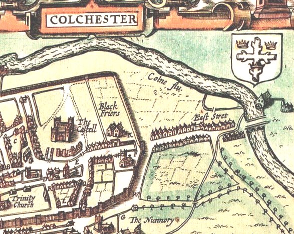
John Speed’s C17th map of Colchester, showing the Grey Friars site (wrongly named as Black Friars) to the east of the castle.
As the C15th progressed the area was beginning to be developed in various ways by different people and in 1478 the Castle Field was encroached upon for gardens. Gifts to the friars continued. In 1516 John Garrington of Munton “bequeaths 10/- (ten shillings) to sing a Dirge (Matins from the Office for the Dead) and Mass for his soul a month after his death”. Another recorded gift was in 1518 from Thomas Paycocke of Coggeshall: “To the Greyfriars of Colchester and the Friars of Maldon, Chelmsford and Sudbury 10/- for a trental and 3/4d to repair their houses”. A trental is a set of thirty requiem masses, offered for souls of the dead. In 1533 Alice Cawston of Tollesbury gave “20/- to pray for my soul and all Christian souls”. Guardians (leaders entrusted with charge/care of the brothers) included John Reylegh in 1419, Walter Bradenham (1458 & 1464) Robert Wotton (1469) Thomas Lexden (1475) Robert Howell (1482) John Tynemouth (1493) and John Gurdon (1536). Some local place/road names will be recognised in this list.
In a study of early C15th Colchester, Richard Britnell comments on literacy and religion. “In 1412 parish organisation gave only minor responsibilities to laymen. The duties of churchwardens required little personal initiative. But literacy was sufficiently widespread to encourage some independence of thought and action in matters of religion. The sons of merchants and other wealthier residents of the town were taught by the master of Colchester grammar school … Poorer men sometimes learned to read English, at least, without a school education of this kind. There were Franciscans from the house in Friar Street who were willing to help small groups of people wanting to read devotional literature in the mother tongue.” 500 years later, literacy teaching in small groups was to return through the adult education service and ended only recently when Essex County Council vacated the site.
The Boundary Walls We know that the north and east boundary walls of the friary were formed by the town walls.The precise whereabouts of the western and southern boundaries pose more of a problem, however.
Although there is a substantial wall running north from behind the present Grey Friars building, all the way down to the northern section of the town wall, we cannot be certain that this is on the line of the actual friary boundary. This wall contains much re-used material such as Roman tile, dressed stone and some very old brick, but also has ‘modern’ brick (mostly Victorian) especially where strengthened. It may be that this boundary originated in the C18th, during the considerable tidying-up of the site and was upgraded in the C19th, during the time of the establishment of botanic gardens on the site.
There is an intriguing doorway, below left, used as the entrance to a storeroom built against the other side of the wall. This may relate to a C18th right-of-way through Hillcrest. Along the wall there are features resembling niches (such as used to house holy statues) probably erected by the convent and school of the Sisters of Nazareth in the early C20th.
John Speed’s map of Essex in 1610, shown previously, has the inset devoted to Colchester. It has the wrong name (black-cloaked friars were Dominicans), but includes some interesting detail, such as the gateway and the unusual wall alignment next to East Gate and opposite St James’ church.
The line of the site’s western boundary is shown on many other maps and especially the ‘North Prospect’ in Morant’s History of 1748. The unidentified early map, below, shows no roads, but the intriguing southern boundary arrangements, as well as buildings, including a gate, quite near the site of the present house. The town wall’s East Gate appears to have a quite substantial building of some kind on its site.

Not much is known about the precise position and layout of the friary buildings. Various documents held in the Essex and Public Record Offices give small clues and these include of course these fascinating, but not wholly reliable, maps. From these we can surmise, however, that there was an entrance through a gatehouse in Friar Street (High Street), which seems to have still been in existence in some form in 1622. The main range of buildings was probably set back some distance from the present line of buildings along the main street. Within the friary site, maps show two lines of buildings running parallel to each other, but there is no real evidence of what they were.
If the early maps are at all accurate, it is possible that the original southern boundary of the friary ran along the line of the rear wall of the present Grey Friars and All Saints houses and turned towards the main road just before the East Gate in the vicinity of the modern Roman Road junction with East Hill.
There are some fascinating fragments of an ancient wall to be seen (below) in the construction of the rear outbuildings. This line is followed by the modern (replacement) wall on the boundary of the garden of All Saints House. Again, if it is in a long-established position, this may explain the changing line of the southern boundary near East Gate shown in earlier C16th and C17th maps.

In ‘Mediaeval Colchester’s Lost Landmarks’, Dr John Ashdown-Hill says, “Unlike St Botolph’s Priory, the Priory of the Franciscan (or Grey) friars is among the most completely lost of all the great landmarks of mediaeval Colchester. Even if they realise the significance of the name most modern Colcestrians probably have little idea what this building might once have looked like. Today it requires a considerable effort of the imagination to visualise, on the site at the top of East Hill, the very large priory church which once stood there crowned with an octagonal belfry and a tall, slender spire. Nevertheless, thanks partly to its impressive site on elevated ground dominating the eastern approaches to the town, this forgotten building must once have been the most notable of Colchester’s landmarks. Its tall spire would have been a feature visible for miles around, rather like the clocktower of the town hall is today. Neither St Botolph’s Priory (on its low-lying site) nor St John’s Abbey (situated off to one side of the town and partly hidden behind the town walls and its own precinct walls) can possibly have rivalled the visual impact of the Franciscan Priory Church, which, in the later Middle Ages, must have been by far the most prominent feature on Colchester’s skyline.”

Possible appearance of the church of Colchester’s Grey Friars – John Ashdown-Hill’s conjecture (for more about Grey Friars and Colchester’s medieval history visit www.johnashdownhill.com)
Other Grey Friars sites As we have no above-ground remains of the friary buildings, and only a limited range of documentary evidence of what they may have looked like, it is necessary to use evidence available on the sites of other Franciscan houses as a guide to what may have been here.

The remains of the church tower of the Grey Friars in Norfolk (above) although it is minus its spire, gives an indication as to what the pattern of building may have been, as does the conjectural drawing (below) of the London Grey Friars in Newgate.

Grey Friars, London, conjecture by H.W.Brewer 1895
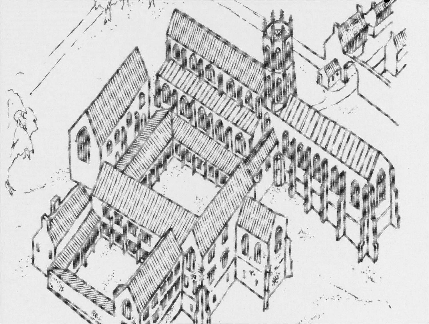
Diagram of Walsingham Grey Friars – adjusted to represent probable Colchester Grey Friars layout – the gateway to High Street would be across top right-hand corner – courtesy John Ashdown-Hill
Colchester’s premises, although similar in layout, including buildings for all main functions, would not necessarily have been on the same scale as others.
<><><><><><><><><><><><><><><><><><><><><><><><><><><><>
Further information and additional illustrations: The content in this section is only a taste of the research findings thus far. For more comprehensive coverage of the subject please consider purchasing the complete book (click on the Purchase button) and regularly visit this site to view the additional material via the News and Announcements and Contributed Resources buttons above.